coming from south australia and driving towards western australia means crossing the nullarbor plain. even today that’s a bit daunting, it’s such a long road through the middle of nowhere. i’d say this stretch is about one third of the distance across our favourite continent.

the first explorers found it very hard going and eyre’s crossing in the mid 19th century was marred by failure (his horses died of dehydration), mutiny (his second in command got killed by part of his crew who then ran off with part of their supplies) and blind luck (they came across a whaling ship who rescued them by providing food & water).

today it’s obviously a bit different, but even with an excellent highway it does take driving through australia to a whole new level. on the one hand there is the monotony of the road, which in it’s own way is exciting as well. at the same time the road follows the great australian bight with it’s steep cliffs dropping into the ocean.

nullarbor means just that: no trees. we can confirm that is at least true for a significant stretch of the road; for us it was the first part as we were driving from east to west. i’d like to stress that while for a large part of the crossing there are not many trees, there are many different kinds of bushed painting the landscape in so many shades of green.

i might get into trouble with any geologist reading this but the nullarbor plain is the greatest limestone bedrock expanse in the world, covering roughly 200.000 sqkm. at it’s wides it measures about 1.100 km across and it forms sort of a crescent shape, between the bight and a wider almost semicircle on top (check the map further up).

despite the warning signs bigger animals don’t venture out onto the plains too often due to the lack of surface water. we didn’t see any and hardly any roadkill either, which confirms the theory.

limestone does not hold water well, that’s the main reason the water does not stay on the plain. there is, however, a massive system of caves underneath it, some connecting to the sea and filled with salt water, others filled with drinking water. the system appears to stretch for many hundreds of kilometers and remains largely unexplored. even with cave diving equipment and a lot of exprience exploring the caves is a dangerous undertaking. aboriginals have known about the caves as well, and some of them have been used in rituals.

we filled up all our tanks in ceduna on the east side of the drive: diesel & water. there is a series of roadhouses across the nullarbor, generally about 100 km apart. fuel is not cheap (at the point of writing we generally pay $1.40 for a liter of diesel, at nullarbor it was $1.86) and water is even more expensive.

the roadhouses don’t get rave reviews by campers and to be fair they don’t have much to work with. the place is pretty dry & deserted and without water there is little possibility to make it look welcoming and friendly.
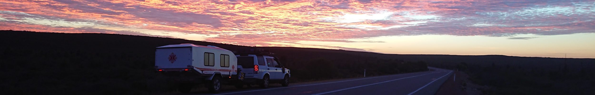
given all of that and the fact that we are thankfully self-sufficient we decided to bush camp at bunda cliffs. look there is even a unicorn farting!

camp is probably the wrong word: it’s more a moonscape a few hundred meters from the road, right on top of the cliffs. i was hoping to get a few drone shots, those would have been absolutely stunning, but the wind was so strong poor zippy would have been blown straight across to antarctica.

the sunset was amazing. as always clouds make the best sunset even better.

the sunrise didn’t disappoint either.

we loved our little camp at the edge of the world. we feel very privileged to be able to experience staying in such a remote and wild place.

no room service available here i’m afraid (don’t tell your wife dc) but there would not be too many hotels with that kind of view. sadly the pool is inaccessible.

the photo above gives a bit of a clue how the steep cliffs might have formed. at eucla pass the road dips from the plateau into a lower lying plain (and climbs back at madura) and the hills run to the north of the road, with a flat expanse to the south.
as the waters rose about 18.000 years ago they clearly reached the limestone hills in some places and not others. if the oceans rise again at some stage in the future all the area in the right of the photo above will be swallowed up and the hills rising to the left will become cliffs. btw aboriginal stories also remember the how the rising water reached the cliffs; their ancestors then took up their shields and transformed into steep cliffs to hold back the ocean.

following the discussions in canberra about man-made global warming (can’t be true, we’re too busy shipping the coal we’re not tipping into our power stations to third world countries) it looks like the biggest inconvenience at that point would be that the road would have to be re-routed. it’s not hard to imagine how that would go: one party would call it a nation-building project, the other would condemn it as vastly overpriced and without clear benefit and then the project would go way over time and budget only to be completed when new technology – say flying cars – would have made it superfluous.

the famed 90 mile straight – sounds better than the 146.6 km straight, that’s for sure. it is really completely straight, however, since it goes a bit up and down at times and because the rest of the road isn’t really a serpentine either it’s difficult to properly appreciate it in all its glorious boredom.

this is also the nullarbor: abandoned cars, most of them bearing signs of accidents and pretty much all of them have been cannibalized for parts. clearly it’s not worth sending a tow truck.

the eyre highway – the official name of the road across from ceduna to norseman in memory of the first white person to cross – is also not nearly as busy as we thought it ought to be. sometimes it takes a while before another car comes by.

on day two of the crossing we took advantage of the two hour time difference with western australia and the fact that we had a bit more light in the evening, and we pushed ahead to fraser range station, about 100 km east of norseman. 1.100 km in two days, not something we would like to repeat. the main reason was actually the fact that the coming weekend is easter and we were concerned that all the caravan parks would be booked out. that turned out to be correct but we found a nice spot in esperance – the last one!

fraser range was a very welcome final stop on our trip across the south of australia. it’s a working cattle station but the owners did an absolutely outstanding job making the park an amazing oasis and great stop. they also cook excellent dinner which we were very grateful for when we arrived after a long day.
so we can now say we’ve achieved another australian milestone: we crossed the nullarbor!
hello western australia.
ps: one thing that really surprised us was the lack of litter on the side of the road. yes, there is the occasional bottle and a bit of paper every now and then but most of the time we didn’t see much rubbish at all. quite a pleasant surprise really. well done australia.